The merchants used to move about in the rivers as they wished, as if in tanks, in the forests as if in their own houses… As he (the king) used to protect the earth so she too gave him gems out of mines, corns from fields and elephants from forests.” (Raghu Vamsha XVII,64,66)
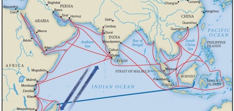
India is almost as large as Europe excluding Russia. The extensive coastline of India fostered inland trade and maritime activity so as to bore the title of country of mariners. Trade was both foreign and inland, sea borne and river borne, export and import. AlBiruni states that the sea-shore of India begins from Tiz, which was near present chabahar in parsion gulf. The large ring of seashore circumphering the southern point of Kanyakumari reached up to the mouth of the great river Ganga in north. Many of the then flourishing ports received the various commodities of export qualities from all quarters of India which naturally required the established trade routes throughout India.
Vedic literature constantly remembers the early path finders. Agni is designated as Pathikrit By burning Vast jungle tracks it created routes. Following such routes the communication was naturally promoted. In the beginning the pleasures and pains of travel depended on the geographical situations of the trade routes and measures taken to safeguard them against predators and wild animals.
The ancient routes followed by the conquerors, rulers, pilgrims, wanderers and merchants did not pass through the smiling green fields on both sides, villages, towns and cities. Majority of the people lived in villages and most part of the country was covered with dense forests through which the roads passed. These roads were often infested with wild animals and robbers lay in wait for travelers. They also had to carry their food provisions. The long routes had to cross rivers, hills, mountains and valleys. We are tempted to think that comparing to modern routes and means of communication, in ancient time it was just impossible to travel such long distances. However, the fact is three thousand years back the traders and merchants traveled long distances of about 2500 or 3000 kilometers from Assam to Gandhar and from Himachal to Vindhyas and thence to the south up to Tamilnadu.
In the first millennium BCE trade and industry were highly organized in India. Srenis were formed as corporations of following the same trade or industry. Scattered references give elite picture of extensive character of the organizations of the various branches of trade and industry. There were guilds of merchants. Sresthi was the president of the guild. This system of guilds was uniform in allover India. The guild also worked as a bank. The wealth and importance of the guilds is indicated in Kautilya’s Arthashastra. In ideal town planning separate quarters were reserved for the guilds.
The guilds received the deposits (Nikshepa) undertaking to devote annual interest for specific charities. . Net balance of the customer was called ‘Nivi’ which was the amount in saving after deducting expenditures incurred and revenues to be realized. The ancient trade routes naturally ran along the commercial cities and towns of different states and kingdoms. The network of trade was such that the merchants found no difficulty in transaction business. For example the promissory note of the merchant of Vaishali could be honored in Mahishmati in Avanti (Madhya Pradesh) or at Junnar in Maharashtra.
India was essentially an agriculturist country however due to the industry and international trade she was also called Goldenland – ‘Suvarna Bhoomi’. Suvarn bhoomi is purely an economic term. In the early centuries India was the exporting country. The streams of gold from all directions flowed toward India. For example annual draining of the Roman empire of its gold valued at fifty million sesterces. In his natural history the contemporary writer Plini gives a caution to the Roman government, “If such drainage continues the empire will have to face a serious crisis of economy.” The very interesting account of inland as well as foreign trade of India is given in the book Periplus of the Erythraen sea, The yavan writer of this book is unknown. He was an Egyptian Greek and a merchant in active trade who personally made the voyage to India in the second half of the first century CE. He describes the inland commercial trading centers and flourishing ports of western and southern India.
Sartha (caravan)-
Inland trade was carried on by carts and caravans. The Caravans (Sartha) were well orgnised containing hundreds of bullock carts, The captain of the Sartha was called Sarthavaha. It had large provisions to maintain the caravan moving on long routes facing many difficulties such as crossing of the rivers, hills, valleys. The sartha required provision of enough food and water (in case of passing through deserts) for calculated number of months, of course their main halts gave them relief where they could fulfill the shortage of required provisions.
Communication of the people and society-
India also has been a country of pilgrimage (yatra) In spite of her unimaginable length and breadth the common people traveled from the holy centers situated on lofty peaks of mountains, the sources of holy rivers of Ganga, Yamuna and Brahmaputra in the north to the sacred Teerthas situated on the shores of ocean in the south. The communication, though very difficult and often adventurous was never impossible. Culturally India always has been an integrated nation in spite of the different sects, languages and even divided in numerous administrative units and political powers.
The system of trade routes was supplementary to the migration of people of the Indian society. Even when the Buddha Bhikshus and Jain Sahdus often traveled to preach, they traveled along the then trade routes. Occasionally they accompanied the caravans for the long journey. The migration of Jain Sadhus and sramanas from Bihar in the north to Sravanabelgola in the south was not an exceptional case. In drought, famine and natural calamities interstate migration was common. We find hundreds of Buddhist caves situated along the ancient trade routes and near the wealthy commercial and industrial towns. The merchants all over India donated generously to the viharas where hundreds of Bauddha acharyas resided. The merchants and trders looked at the sthaviras (chief Bhikshu) as trusty and deposited their goods with them.
Busy ancient trade routes-
Old Pali texts indicate some of the ancient trade routes in use atleast 2500 years back. The caravan of the merchant prince Anathapindika going southeast from Sravasti to Rajagriha passed along the foot of the hills up to Kushinara. The route from Sravasti to Rajagriha had twelve halts including one at Vaishali, with only a single crossing of the river Ganga. Another route led from Sravasti southwest to Paithan with six intermediate halts and frequent crossing of rivers. A third route led westward to Sindha the home of horses and asses and to Sauvir (Saurashtra) and its seaports. The then old grand trunk road leading from Rajagriha the capital of Magadharan through Banaras, Saket and Sravasti towards Taxashila and the frontiers linking India with central and western Asia. This distance was over 18 hundred kilometers. Apart from these arterial routes the whole country was connected by a network of roads, some of which at any rate had milestones to indicate distances, Amenities were provided for travelers in the shape of shady trees, rest houses and wells on the roadside. The means of conveyance included litter, sedan chair, bullock carts and horse carriages. Rich people rode on elephants. Common people used camels, horses and asses. The king, princes and wealthy prople used chariots. The Mahabharata gives an account of the roadways, It refers to Uttarpatha, the northern highway which linked the territory of Kirat, Kamboj, Gandhara and Yavana, Many roads lead to Dakshinapatha the high way for south india passing through the city of Avanti and Rikshavati. This road led to Vidarbha and other to Kosala. It linked the different states such as Andhra, Guha, Pulind, Shabara, Madrak etc. of south India. The roads were in better condition in the period of Mahajanapadas in the north. The network of Dakshinapatha was also remarkable. Almost all the flourishing ports were linked with the Inland commercial centers. The merchants from Kalingpttanam, could go to Bharukachcha (Bhadoch) in Gujrata. It was the central highway. With the spread of Mauryan empire almost all the capital cities of Political powers were linked by state high ways and national highways.
The interesting thing is that most of the present state highways are exactly on the track of ancient trade routes. To cross the high mountains, ghats (passes) were used in ancient time. Most of the Ghat routes crossing western and eastern mountain ranges, Vindhya and satpuda ranges have same names. Only that, some of them have been still in use and are built with tar or concrete with modern construction technology. The track, once witnessed the long trains of bullock carts of great caravans. The same track is now flooded with the cars, buses and heavy vehicles.
Mahamarga- the national Highways-
The various ancient routes can be grouped under three divisions, Mahapatha,Vanikpatha and Rajapatha. Magadha was the national highway leading to all the four quarters of India. Mahapatha can be termed as Mahamarga. We can lay out the national highways which were the important trade routes.
Uttarpatha- Rashrtiya Mahamarga-
This highway covered the northern areas from kamarupa (Assam) up to North West frontier. It linked Manipura, Mahasthan, Gaud, PundraVardhan, Vaishali, Kushinagar, Kapilvastu, Sravasti, Ahikshetra, Indraprastha, Takshashila, Purushpur (Peshavar) and Pusharavati. Kautilya designated this national highway as ‘Haimavata Mahamarga’.
An important national highway started from Tamralipti (present Tamluk on Suvarnarekha river in Bengal) which was the international port as well as emporium- Crossing Gaya, Kashi, Prayaga, Kanauja it joined Uttarpath Mahamarg at Indraprastha.
Another important Mahamarga started from Indraprastha and crossing Agroha, Sirasa, Mulasthana (Multan) reached Bolan, where the Aparantapath merged.
Dakshinapath- Rastriya Mahamarga-
Pataliputra (Patana) was the capital of vast Mauryan empire. Naturally this mahamarg was the longest route going to south India. It had several branches bifurcated from important trade centers to the east and west. Main route starting from Pataliputra reached Bejawada crossing Rajagriha, Bhita Tripura, Nagpur to Vastagulm (Vashim in Vidarbha).
Second important route starting from Pataliputra ran to Kanauj, turning south to Vidisha (Madhya Pradesh) it entered in Maharashtra- from Maharashtra it proceeded to Karnataka through karnataka it went to Tiruchirapalli in Keral- finally destined to Rameshvara. The famous ports on Ratnakar (Arabian sea) were connected to this road. The commodities of export value from the north and central India thus reached on the ancient ports.
Another important route from Ujjain entered Gujaratha, the ancient commercial state with internation emporium and harbors.
Purvantapath Mahamarg-
This Mahamarga started from Gauda and covered the whole eastern coastal regions including Tamratipti, Kaling, Puri, Vishakhapatanam, Masulipattanam, KanchiPuram, and kaveripattanam. Thence it proceeded to meet national highway coming from kanauj so as to reach up to Rameshvar.
Aparantapath mahamarg-
This important route coming from far western point of Bolan crossed Sindha and entered Gujarata. Crossing the commercial capitals of Patana and Bharukachcha it entered Sopara the celebrated international port (Near present Mumbai). Thence it proceeded to south up to kanyakumari. Aparant is the ancient name of kokan. There were sevan kokans which included the coastal area of Maharashtra, Karnataka and Kerala. Apart from these main national trade routes there must have been several alternate routes.
Vanik Patha-
The highways were naturally served as trade routes, as today we see that the tar-roads are commonly used by automobile vechiles as well as bullock carts and camel carts. Still some trade routes were specially called vanik-patha. For example the production of the salt is not everywhere. Many janapadas depended for the supply of salt on particular caravans visiting annually. The rice requires particular environment, in coastal area it is the main crop. Supply of rice to the regions where rice could not be cultivated was the responsibility of caravans. Such necessities promoted the trade. For the regular supply many trade routes became in use. Some of the routes were created by the administrations of the regions. The caravans carried the supply of rice, corn, salt, copra, bettlenut, almond, cardamon, paper, clove, cinnamon, nutmeg raisin, date and many such commodities regularly. Along such trade routes temporary markets were established, where the people from surrounding villages and small merchants visited to purchase the commodities on retail as well as whole sale rates.
The network of such Vanik-pathas was in all over India. There were short roads joining villages and long roads joining commercial towns. In Uttarpatha there were vanik-pathas joining the headquarter towns of the janapadas. In Dakshinapatha there was a remarkable network of vanikpathas as the most of the export of commodities was through the sea ports and riverine ports. Due to the diminishing breadth of south India it was comparatively easy to establish the communication through the short vanik-pathas. More over the means of transport of elephants was advantageous. The products of the forests were transported using elephants.
The political powers were alert to the construction and maintenance of the mahamarg as well as vanik pathas. They also provided security. The governments were naturally interested in collecting tolls, custom and revenues that enriched their treasury.
Aparant mahamarg was very important. Kautilya regarded the routes leading to the south as more important than those leading to Himalayas, Uttarpratha brought to market the supply of blankets, skins and horses. Aparant path facilitated the supply of valuable commodities as diamonds, pearls, gems, gold, conch shells and precious stones for which southern India was famous for ages, southern routes passed by a larger number of mines.
Classification of ancient routes-
Due to the geographical situation the ancient routes may be classified in different groups.
- Sthala patha : trade routes in plain land.
- Vana patha: the forest road, and those leading to elephant forest were called Hastikshetrapatha.
- Shanku patha: the hilly road.
- Kari patha: Sea-shore route linking the ports and harbors. The routes were also classified according to the of vehicles.
- Amsha patha: The road specially for draft wagon, known as Amsha.
- Chakra patha: The road for wheeled cart which admitted large volume of traffic.
- Rathya patha: The road for chariots (10′ to 32′ wide road).
- Parirathya : By pass road for chariots.
- Uprathya: Lanes for chariots.
There was a systematic management for the trade routes and mahamargas. These routes were the important veins of the national life as well as the daily life of the society in general. India was second to none in the world in the industry of cotton, iron and luxurious goods. Inland trade routes were the vital part of suvarnabhoomi. The traders and merchants moving all over india on land and outside india in the world over the water were not only moneymakers.
They were the torch bearers of glorious Bharateeya culture. They have played wonderful part in integrating the Bharatavarsha right from vedic period to the present age.
-Dr. Sharad Hebalkar